ExynAI Nexys: Precision Mapping and Visual Inspection for Construction
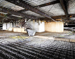
ExynAI’s Nexys offers a mobile mapping solution that combines LiDAR-based SLAM technology with ground control points (GCPs) to produce accurate 3D point clouds for construction sites. The use of GCPs helps address drift and maintain global accuracy, providing reliable data for monitoring construction progress and ensuring alignment with project specifications. This can reduce the likelihood of errors that might lead to costly rework.
Additionally, Nexys integrates photospheres into the point cloud data, enabling detailed visual inspections of specific areas. This feature allows users to view panoramic images within the point cloud, facilitating early detection of issues and supporting timely corrections. By integrating accurate mapping with visual inspection capabilities, Nexys aims to help keep construction projects on schedule and within budget.
For more information
Categories: Geotechnical Services Sensors
2024-08-30 | Exyn Technologies | United States | Views 532
More from Exyn Technologies