Wingtra Introduces WingtraGROUND

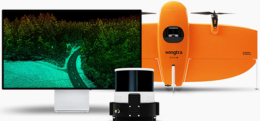
Wingtra has launched WingtraGROUND, an all-in-one survey kit designed to improve efficiency and accuracy in data collection. The kit includes receivers integrated with WingtraCLOUD, enabling a seamless workflow with high-precision results. Users can follow step-by-step guidance to ensure proper ground setup, eliminating manual errors and optimizing survey operations.
The company says that WingtraGROUND supports both relative and absolute positioning, with base logging capabilities of up to 22 hours. It integrates with WingtraCLOUD for PPK image geotagging and processing options, ensuring precise and reliable data. The included WingtraRECEIVER, based on the Emlid Reach RS3, tracks multiple satellite signals and achieves horizontal positioning accuracy of 5 mm + 0.5 ppm. With an IP67 rating, it is designed for durability in challenging environments.
For more information
Categories: Geotechnical Products Geotechnical Services Surveying Equipment
2025-02-10 | Wingtra AG | Switzerland | Views 1226
More from Wingtra AG